CRISIS MANAGEMENT
PROJECT PROGRESS
Odelouca & Arade rivers 3D LIDAR Mapping
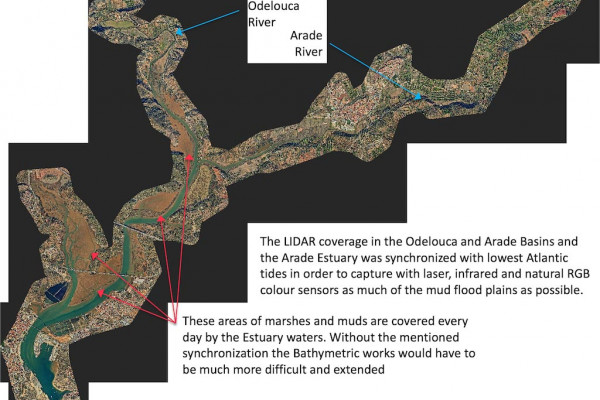
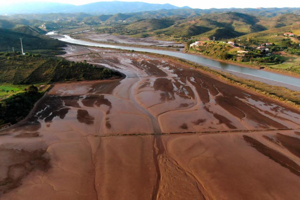
The high-precision 3D mapping works of Work Package 6 are underway and the capture and processing of the maps obtained with airborne LIDAR technology has already been completed. These works have covered the basins of the Odelouca and Arade rivers from their reservoirs closest to the Algarve Coast, as well as the Arade estuary and its outlet to the sea
AA-FLOODS Project in Algarve. Águas do Algarve.
Águas do Algarve participates in the AA-FLOODS project with the aim of improving the prevention and management of flood emergencies. In this video report, the vice-president Ms. Isabel Soares explains the problem of Climate Change in the Algarve, the problem of floods and droughts, the role of the public company Águas do Algarve in the ...
In Floods Crisis Management inter-administrative coordination plays a special role, and in a singular way, the management of reservoirs:
Floods put hydroelectric, irrigation or regulation dams at risk and therefore reservoir’s managing authorities discharge large volumes of water before when its pressure overpasses certain levels.
These discharges occur just when the rivers are at the limit of overflowing, or already overflowed, and aggravate the effect of flooding on downstream populations.
Águas do Algarve, as reservoir manager, will develop with the support of all partners, a Pilot Experience to improve discharge protocols with risks and social criteria.
Specific attention will be paid to coordination with the stakeholders involved in Risks prevention and Floods Emergency management.
The Pilot will simulate different scenarios of torrential rain, flood, volumes of discharge of the aforementioned reservoir, discharges of two other reservoirs not managed by Águas do Algarve, and all this affected by the tidal dynamics of the Portimão estuary, which affect the cities of Portimão and Silves (within the pilot area).
Special attention will receive the improvement of e protocols and coordination tools between the different bodies that intervene in an Emergency. The objective is to share information in real time, establish clear chains of command and action protocols, and contribute to developing Emergency Management as close as possible to those affected (therefore at the local scale).
ACTIONS
ACTION
Pilot 3- Reservoirs’ Water Discharges Management
Management of Water Discharges from Reservoirs in periods of heavy rains and / or floods.
AA-FLOODS will model over new LIDAR 3D maps hydrological and hydraulic scenarios of intense rains in the basins of Odelouca and Arade rivers and Portimão estuary.
The analisys of torrential rains, extreme flows, simultaneous Atlantic tides and different volumes of water discharge from Odelouca and Arade reservoirs will allow accurate and updated Flood and Risk Maps, a Flood Risk Management Plan and unprecedent Water Discharge protocols that will become a model for the AA.
As a result we’ll obtain a Guide for Planning, Management & Stakeholders Coordination of water discharges from reservoirs. This Guide will establish how to manage Water discharges thanks to the experience on Odelouca reservoir: volumes, impact of these on the inhabited areas, communication and coordination protocols that must be activated to avoid material and human damage.
The Improvement in the coordination of reservoirs’ water discharges during flooding and torrential rains periods will be achieved through modelling water discharge effects. This will allow to accurate Preventive planning and enhance the Coordination and Cooperation Protocols with stakeholder.
ACTION
Improving the Coordination among Emergency Management bodies
The Project will rely on the Diagnosis of AA States Policies against Flood Risks to prepare a proposal for improvement in the coordination between the authorized institutions involved in emergency management in the Member States participating in AA- FLOODS.
The extreme scenarios tested in Pilots 1, 2, 3 plus recent real experiences in the UK and EI will be exploited, and projects such as FRAMES (North Sea interreg) will be capitalized
The output will be enhanced Coordination Protocols: an Operative paper with detailed proosals to enhance effectiveness of Crisis Management due to a enhanced Coordination of Emergency Bodies and the use of Local Flood Risks Management Plans to guide the interventions.
These new Protocols will allow the Improvement in the rapid response of the Intervention and Emergency Corps for Harm Reduction through the development of capacity-building initiatives directed at actors involved in managing and preventing risks that will improve the effectiveness of Emergency Bodies.
ACTION
Promote the use of real time information in Response Planning
To achieve greater efficiency in crisis management there is a need to develop:
- Protocols to Inform to Local Authorities for a better coordination during the event with clear objectives and hierarchies and clear identification of main actors involved (decision-makers, infrastructure managers, emergency responders, other) and their roles.
- Enhanced Real Time Information to population through Social Networks during the event enhancing the way the information is created, shared and understood by the population.
AA-FLOODS will consequently implement Strategies for enhancing resilience considering both short- term and long-term impacts.
They will include cost benefit framework to rank alternative proposals; harmonised Social Cost Benefit and Life Cycle Cost Analysis protocols; interactions with Stakeholders/End Users developed via Delphi Panels and Workshops; and Resilience indicators score system .
The development of capacity-building initiatives directed at actors involved in managing and preventing risks, so as to avoid the negative effect of fake news and, instead, take advantage of social networks as a useful tool to improve crisis management will help the rapid response of Local Authorities and an enhanced reaction of population affected, in order to reduce harms.


