
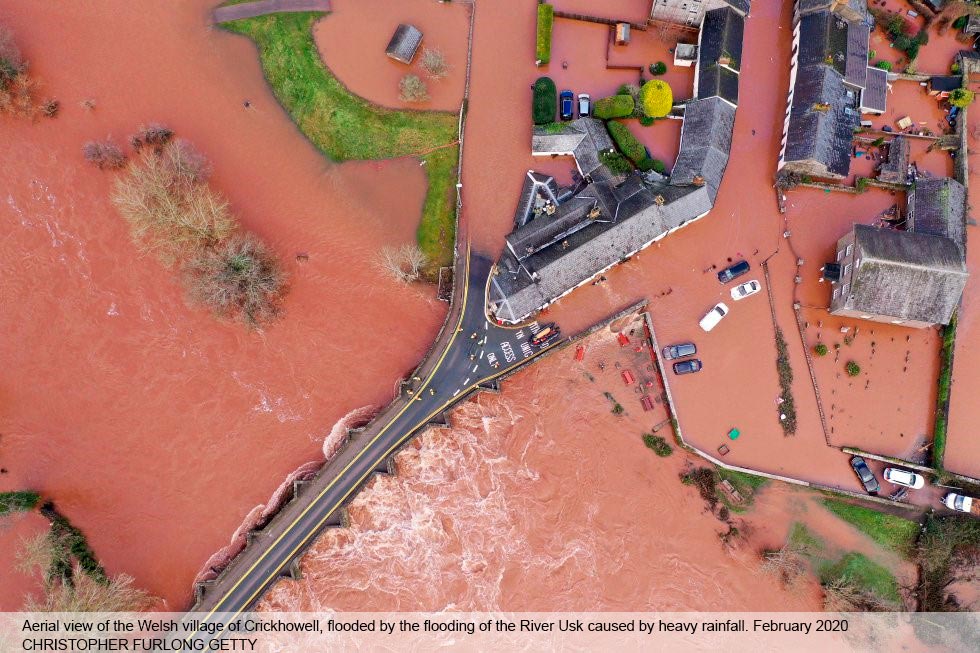
Between November 2019 and February 2020, severe winter flooding occurred across the United Kingdom. Following the first wave in November, isolated incidents were reported in December and January, before the second main wave of flooding, caused by Storms Ciara and Dennis, occurred in February 2020, exacerbated by already very wet antecedent conditions. February rainfall was the highest since records began, in 1766, in England and Wales with 169.6 millimetres.
The recent flooding in the UK has reignited a debate about the building of new homes on floodplains. An analysis of planning documents (The Guardian, 2020) reveals that 11,410 new homes have been planned for land the government considers high-risk in the seven English counties where thousands of properties have been devastated by flooding since November.
In Shropshire, where a major incident was declared and residents were evacuated during Storm Dennis, 764 homes are set to be built in areas with a high flood risk. In Doncaster, where the Fishlake area was flooded in November, nearly 4,000 homes are intended for such flood zones. The government is facing renewed calls to review its housing strategy as experts, local authorities and insurers warn that building on floodplains is increasing the danger to thousands of people from extreme storms.
Concerns have also been raised that homeowners who buy new properties on at-risk land are in “potential insurance blackspots” as they are not eligible for cover under the government’s Flood Re insurance scheme, potentially leaving them liable for crippling costs in the event of damage.
The UN Intergovernmental Panel on Climate Change (IPCC, 2013) indicates that the UK will receive about 10 per cent more rainfall on average per year by 2100 (right) compared to 1986-2005 (left) – Figure below. In addition to an increase in total rainfall, the UK is very likely to see more frequent high intensity rainfall events, and there’s already evidence that heavy rainfall events are getting more frequent in the UK (Met Office, 2018) increasing flood risk including that via sewer systems. Flooding costs are likely to escalate with the rising risk of flooding and the IPCC report that “Climate change could increase the annual cost of flooding in the UK almost 15-fold by the 2080s under high emission scenarios.”
Whilst traditional flood defences, coupled with improved planning, will continue to play a vital role, there is a growing recognition in the UK of the need to take a more strategic, whole river catchment approach to managing flood risk; one that recognises that activities in one part of the catchment can influence flooding somewhere else. This catchment wide approach is commonly based on measures that work with natural features and processes to manage the sources and pathways of flood waters, or what is commonly referred to as natural flood management. Natural flood management (NFM) typically involves slowing or storing flood water and covers a spectrum of techniques inclduing full-scale restoration of the course of a river, tree planting, leaky dams and the creation of wetlands and ponds. In addition to benefits for flood risk, these techniques can also often provide improvements in biodiversity, water quality, and carbon storage too (SEPA, 2015). The NFM approach also encompasses soil management which, if undertaken sustainably, can maintain and restore organic carbon levels and water retention properties, thereby helping to diminish flood risk.
In the urban environment the natural approach includes the use of green infrastructure or sustainable urban drainage systems (SuDS) to slow the flow of water. Such features, that include ponds, wetlands, urban woodland, green roofs and permeable pavements, all help to reduce flood risk (EEA, 2017) and, in some cases, provide other benefits too, such as improved water quality and enhanced community health and wellbeing.
Adopting a truly catchment wide approach to flood risk management requires collaboration between several key stakeholders including regulatory authorities, local authorities, catchment partnerships and other environmental NGOs, landowners, businesses and, local communities. The provision of data and evidence is also key to addressing flood risk in a holistic manner, helping to identify cost-effective strategies.
References
EEA (2017). Green Infrastructure and Flood Management. https://www.eea.europa.eu/publications/green-infrastructure-and-flood-management
Guardian (2020). More than 11,000 homes in England to be built on land at high risk of flooding
https://www.theguardian.com/environment/2020/feb/23/more-than-11000-homes-to-be-built-on-land-at-high-risk-of-flooding
IPCC 5th Assessment Report (2013) – Summary for Policymakers; https://www.ipcc.ch/site/assets/uploads/2018/02/WG1AR5_SPM_FINAL.pdf
Met Office (2018). State of the UK Climate 2018. https://rmets.onlinelibrary.wiley.com/toc/10970088/2019/39/S1


